The RAISE project focuses on infrastructure improvements along the CityLink Blue and CityLink Orange lines to provide faster, more reliable transit and improved pedestrian safety.

Project Details

Who is leading the RAISE Transit Priority Project (RAISE Project)?
The Rebuilding American Infrastructure with Sustainability and Equity (RAISE) Transit Priority Project – or RAISE Project for short – is a collaborative effort between the Maryland Department of Transportation Maryland Transit Administration (MDOT MTA) and the Baltimore City Department of Transportation (BCDOT) with the assistance of other agencies such as the Maryland Department of Transportation State Highway Administration (MDOT SHA), Baltimore County and BGE.
Where are the RAISE Project limits?
The RAISE Project spans from the Centers for Medicare and Medicaid Services (CMS) in western Baltimore County through Baltimore City, including Downtown, to the Fox Ridge community in eastern Baltimore County. The RAISE Project will focus on two of the highest-ridership routes in the MDOT MTA transit system - the CityLink Orange and CityLink Blue.
Project limit map
What improvements are being considered as part of the RAISE project?

The RAISE Project improves the reliability, speed, safety, and accessibility of transit by including the following elements:

  • Dedicated Bus Lanes (DBLs) on select congested segments along the Blue & Orange bus routes (subject to change as the design advances):
    • Along Edmondson Avenue from Swann Avenue to North Paca Street
    • Along Baltimore Street from North Gay Street to President Street
    • Along Fayette Street from North President Street to North Highland Avenue
    • Along Eastern Avenue from Bayview Boulevard to Dundalk Avenue
  • Transit Signal Priority (TSP) at up to 60 traffic lights along the corridor to prioritize bus movements
  • Bus stop upgrades at over 100 locations - ADA compliance, shelters, benches, trash cans, pedestrian lighting
  • Signage upgrades at high-transfer activity ‘hubs’ - wayfinding and real-time arrival information
  • Pedestrian & bicycle safety improvements - trees, lighting, curb extensions, sidewalks, new crosswalks
  • Bicycle connection between Downtown Baltimore and West Baltimore MARC rail station
  • Electric vehicle charging stations, in coordination with BGE
What improvements are being considered for pedestrian and people with mobility challenges?
This Project emphasizes improving the safety of pedestrians and people with mobility challenges by addressing infrastructure gaps, missing links, and barriers to access that disproportionately impact those who do not have alternative means of transportation. The RAISE Project will improve ADA access to over 100 bus stops to allow individuals with disabilities to access transit and sidewalks that are currently inaccessible. These improvements will be focused in areas with the highest crash rates, which are disproportionately in communities with higher poverty rates.
Will the RAISE Grant add additional service along the project corridor?
No. But if the buses can be more reliable and travel faster, they can make more trips in a given amount of time.
What is the RAISE Project schedule?
MDOT MTA and BCDOT have worked together and with local stakeholders to identify a draft (30%) concept design for Dedicated Bus Lanes and bus stops along the corridor with high transfer activity. Pre-construction activities are anticipated to be completed by June 2024, including compliance with the National Environmental Policy Act (NEPA). At this time, construction is scheduled to be substantially completed in 2027, with all funds expended by September 30, 2029.
project timeline
How much will the RAISE Project cost and where is funding coming from?
The $50 million project will be funded by a $22 million grant from the United States Department of Transportation’s (USDOT) 2021 Rebuilding American Infrastructure with Sustainability and Equity (RAISE) program, as well as a $18 million investment from the Maryland Department of Transportation and $10 million from the Baltimore City Department of Transportation. Visit mta.maryland.gov/articles/325 for more information.
Will any property impact or displacements be required for the RAISE Project?
No residential or commercial displacements would occur as a result of this project. The RAISE Project would only have potential impacts to existing bus stops, curb ramps and sidewalks, of which the majority reside on State, City or County owned property. Small amounts of property may be needed for this project.
What environmental reviews have occurred or will occur in the future for the RAISE Project?
MDOT MTA has already begun investigating the potential for environmental impacts from the RAISE Project and expects them to be minimal. This Project is expected to qualify for a Categorical Exclusion under the National Environmental Policy Act (NEPA). MDOT MTA will work with federal partners to complete the NEPA process that will run concurrently with preliminary engineering and design of the Project.

Project History

How is the RAISE Project different from the RTP East-West Corridor Study?

The Regional Transit Plan (RTP) identifies transit corridors that together would create a strong transit network in Central Maryland. More information from the RTP study will be released in the Spring of 2022 for two transit corridors: North-South (Towson to Downtown Baltimore) and East-West (Bayview to Ellicott City).

While the RTP study is evaluating new major transit alternatives along these two corridors in the form of Bus Rapid Transit (BRT), Light Rail Transit (LRT), and Heavy Rail Transit (HRT), the RAISE Project will improve existing transit services along the CityLink Blue and CityLink Orange routes through the addition of dedicated bus lanes, transit signal priority, and bus stop amenities. The RAISE Project is scheduled to begin construction as soon as 2024 while alternatives associated with the RTP could take 7 years or more to implement.

project study timeline
What plans for rapid transit or a transit priority corridor have been developed for the RAISE Project corridor?

An east-west rapid transit corridor in Baltimore has been studied for over 50 years, and the route from east to west along the CityLink Orange and CityLink Blue alignments continues to have among the highest demand for highcapacity transit in the region. Various plans, listed below, have been developed for this project corridor:

  • Baltimore Region Rail System Plan (2002)
  • East-West Transit Connector Study (2002)
  • Baltimore Red Line Alternatives Technical Report (2008)
  • QuickBus Service Analysis (2009)
  • BaltimoreLink (2017)
  • Dedicated Bus Lanes Study (2020)
  • Central Maryland Regional Transit Plan (RTP) (2020)
  • RTP East-West Corridor Study (2022)
  • The analyses and recommendations in these plans recognize the RAISE Project corridor as one of the highestpriority corridors in the Baltimore region.

    Several “early opportunity” corridors were identified in the RTP as being suitable for near-term implementation. The RAISE Project corridor was one of only four corridors to meet all transit readiness conditions and was prioritized for near-term transit investments. While plans for this corridor have identified different modes and alignments over decades of planning, they have all consistently identified the need for additional transit investment to link to the following communities:

    • Edmondson Village
    • Midtown Edmondson
    • Poppleton
    • Westside
    • Charles Center
    • Highlandtown
    • Bayview

    Public Comment, Equity & Accessibility

    How may I become more involved in the RAISE Project?

    On-going feedback is encouraged throughout the life of the RAISE Project. You may:

    In Fall/Winter 2022, MDOT MTA and BCDOT are sending “Street Teams” to visit various locations along the project corridor. We will talk one-on-one to users of the corridor to gather feedback on needed improvements and distribute project information. If you see us set up at the RAISE Project kiosk, stop and say Hello!

    We will also be announcing additional meetings including a virtual Bike Connections meeting and the two (2) In-Person Open Houses in December 2022 (hosted by MDOT MTA and BCDOT), which will explain the RAISE Project in more detail and request feedback on conceptual design plans (30% design).

    Note: If you would like the project team to bring the kiosk to your location for a single event or for a multi-day stay, please send an email to info@RAISEBaltimore.com.

    project timeline
    What if I cannot attend a virtual public meeting or in-person Open House for the RAISE Project?
    Don’t worry if you cannot attend a meeting. All information presented at our public meetings will be available on this project webpage for viewing, and the project team can be reached at any time using the contact information provided.
    How may I comment on proposed improvements for the RAISE Project?

    You may provide comments via email to info@RAISEBaltimore.com or by completing a comment form. All comments received will be given equal consideration.

    You may comment directly within interactive mapping developed for this project: RAISE Baltimore Transit Priority Project Comment Map

    Featured within this map are the locations of existing CityLink Orange and CityLink Blue Line bus stops, pedestrian facilities, transit signal priority areas, and proposed and existing dedicated bus lanes.

    Comments and concerns can be expressed using pushpin icons for the following categories:

    • Bus Stop Amenities
    • Bus Operations
    • Traffic Congestion
    • Pedestrian / Bicycle Facilities
    • Americans with Disabilities Act (ADA)

    If there’s a location where you’d like to comment, please add it to the map by following these steps:

    • 1. Select an icon from the menu bar on the right
    • 2. Click on the map where you want to add the feature
    • 3. Fill in the pop-up with any additional comments that you may have
    • 4. Click Save to finalize the addition

    Title VI & Accessibility

    Who do I contact if I need special accommodations under the Americans with Disabilities Act or require language translation services?

    If you have any questions or need assistance, please contact the MDOT MTA Transit Information Contact Center – 410-539-5000; 866-743-3682; TTY 410-539-3497; MD Relay users dial 7-1-1. Or, MDOT MTA Office of Equal Opportunity Compliance Programs (EOCP) -- ADA/Title VI Coordinator at (410) 767-3944, email address: MTAEqualAccess@mta.maryland.gov, or, Bart Plano at bplano@mta.maryland.gov.

    Transit Basics

    How are Dedicated Bus Lanes being evaluated?

    Dedicated bus lanes will be evaluated by their ability to improve the following metrics:

    • Travel Time Reliability - The consistency of travel time from day to day and at various times of the day.
    • Travel Delay - Anything which interferes with bus travel including traffic congestion, crashes, or operational failure. Travel delay is the main source of poor travel time reliability.
    Who may use Dedicated Bus Lanes (DBLs)?
    Only buses, emergency vehicles, school buses and bicycles are permitted to travel in the bus only lanes. Other vehicles are only permitted to enter a bus lane in order to make a right turn at the next intersection or to access parallel parking spots next to the bus lane.
    How will Dedicated Bus Lanes be enforced?
    Baltimore City Transportation Enforcement Officers, the Baltimore Police Department, and MDOT MTA Police handle violation enforcement. Parking or stopping in a bus lane may result in a $250 fine, and driving in the bus lane may result in a fine up to $500.
    What changes can be expected along the RAISE corridor from the proposed improvements?
    Creating dedicated bus lanes and accommodating bicycles along the RAISE corridor will have an impact on the movement of automobiles; however, it will also create several benefits for the many residents that depend on transit to access jobs, education, and recreational activities. The dedicated bus lanes will improve travel times and transit reliability for two of the highest ridership routes in our system and will overall be beneficial to the transportation network. The proposed improvements will result in removal of some parking spaces, reduced vehicular capacity, and slight changes in traffic operations. Potential impacts are being investigated now based on the proposed improvements and will be refined as the project progresses. If parking removal is needed, MDOT MTA and BCDOT will provide notifications to affected stakeholders and will identify alternative parking options to the best of their ability.
    Once the Dedicated Bus Lanes (DBLs) open and transit signal priority (TSP) enhancements are implemented, what travel time savings can be expected?
    In 2019, MDOT MTA published the “Dedicated Bus Lanes Before and After Study,” which presented findings on the effectiveness of dedicated bus lanes derived from data collected before and after the implementation of BaltimoreLink bus network restructuring. MDOT MTA found improvements in travel times for 79% of the bus lanes during peak periods, and travel time savings averaged 9.3% per corridor. Furthermore, bus lanes have not had a noticeable effect on general traffic, with additional travel times averaging less than one minute.
    Is this considered a Bus Rapid Transit (BRT) project?

    No. The RAISE Baltimore project’s purpose is to provide enhancements to the existing CityLink Blue and CityLink Orange bus routes; whereas a BRT project would include additional service, upgraded stations, dedicated guideway and the potential for new branded vehicles.

    Median Running Dedicated Bus Lanes, which would function similar to a more complex Bus Rapid Transit (BRT) system, have been considered along segments of the RAISE corridor. Results show that this type of bus lane is not cost-effective, would incur greater impacts, would still require local bus service, and therefore will not be considered further for the RAISE Baltimore project.

    The RAISE Baltimore project’s purpose is to provide enhancements to the existing CityLink Blue and CityLink Orange bus routes; however, MDOT MTA and local jurisdictions are currently researching cost estimates for other projects that could be implemented mid- and long-term along the East-West Corridor that include BRT, Light Rail Transit (LRT) and Heavy Rail Transit (HRT).

    What impact will the pandemic have on this Project and how will the Project account for these considerations?
    While COVID-19 likely will not have a direct impact on the Project, it could continue to have an impact on the supply of raw materials and fabrication of construction components. MDOT MTA will work to realistically factor in these potential delays into the Project schedule.
    How can I find out where the proposed improvements are located?

    You can see proposed improvement locations by viewing mapping at the project website: RAISEBaltimore.com, attend an Open House, or talk with a project team member at a pop-up meeting along the RAISE corridor.

    You may also request a virtual or in-person community meeting with the project team by sending an email to info@RAISEBaltimore.com or by submitting a comment on the project website Interactive Map.

    Glossary

    Americans with Disabilities Act (ADA)

    The Americans with Disabilities Act (ADA) of 1990 prohibits discrimination and ensures equal opportunity and access for persons with disabilities. This act works to ensure nondiscriminatory transportation in support of its mission to enhance the social and economic quality of life for all Americans.

    Complete Streets

    Complete Streets - Complete Streets will be designed to address safety, be accessible, improve mobility, ensure equity, and reflect Baltimore’s unique communities, while prioritizing the movement of the streets’ most vulnerable users. Baltimore’s citywide modal hierarchy—recommended by the Complete Streets Advisory Committee and endorsed by BCDOT—is prioritized as:

    1. Walking
    2. Cycling / Public Transit / Micromobility
    3. Taxi / Commercial Transit / Shared Vehicles
    4. Single Occupant Automobiles

    Complete Streets Manual March 2021

    Curb Extensions (Bus Bulbs)
    Curb Extensions (Bus Bulbs) are widened sidewalks that, when built at bus stops, expand the bus boarding area into the travel lane. By allowing buses to stop within the travel lane, buses avoid having to wait to re-enter traffic after stopping, creating travel time savings for bus riders. Curb extensions also improve pedestrian safety by shortening the crossing distance at intersections and physically and visually narrowing the roadway to slow vehicular speeds.

    Photo: MDOT MTA Transit Priority Toolkit

    curb extensions
    Dedicated Bus Lanes (DBL)

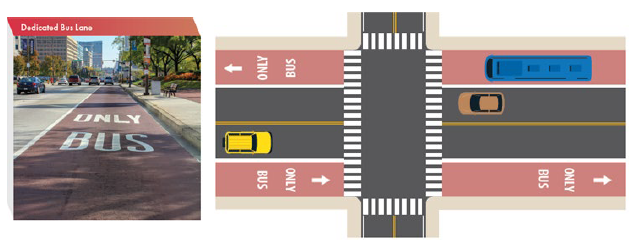
    Dedicated Bus Lanes (DBL) convert existing travel or parking lanes in each direction to a bus-only lane using striping, markings, red paint and signage. Red paint emphasizes that the lane is for transit only and deters drivers from using the lane, thus reducing the amount of time that buses are slowed by traffic congestion. DBLs would also allow safe shared use with bicycles.

    Photo: MDOT MTA Transit Priority Toolkit

    dedicated bus lanes
    Electric Vehicle (EV) Charging Station

    An Electric Vehicle (EV) Charging Station is a piece of equipment that supplies electrical power for charging plug-in electric vehicles (including hybrids, neighborhood electric vehicles, trucks, buses, and others).

    Far Side Bus Stop

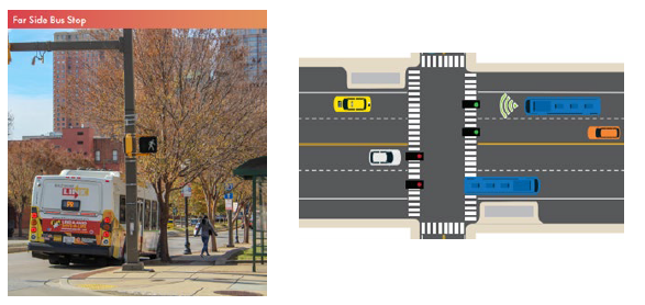
    Far Side Bus Stop - When a bus stop is placed on the far side of an intersection, the bus moves through the intersection then pulls over to the bus stop. Generally, “far side” bus stops are preferred since they’ve been shown to reduce stop time and increase safety for motorists, pedestrians, and cyclists.

    Photo: MDOT MTA Transit Priority Toolkit

    far side bus stop
    Real-time Information Signs (RTIS)

    Real-time Information Signs (RTIS) are digital signs that display route destinations, frequencies, and estimated arrival times for buses, pulling data from several information technology systems to provide valuable information for bus riders. Buses in MDOT MTA’s system are equipped with GPS systems to report real-time data, which is shared through a mobile app and real-time signs at several transit hubs.

    Transit-Oriented Development (TOD)

    Transit-Oriented Development (TOD) is a type of urban development that maximizes the amount of residential, business and leisure space within walking distance of public transport. It promotes a symbiotic relationship between dense, compact urban form and public transport use.

    Transit Signal Priority (TSP)

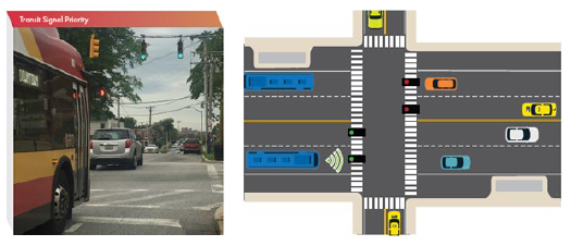
    Transit Signal Priority (TSP) is a technology that adjusts the traffic signal timing when transit vehicles are present to allow them to more quickly travel through the intersection. This technology can significantly reduce bus delay, which improves travel time and reliability for transit riders. MDOT MTA has implemented TSP at 66 intersections in the MDOT MTA system and a 2018 analysis showed that run times along certain segments implementing TSP dropped by as much as 20% during peak hours.

    Photo: MDOT MTA Transit Priority Toolkit

    transit signal priority